
The TGO Challenge is an annual backpacking event that lasts for 15 days and involves backpacking coast to coast across Scotland, a distance of 180-200 miles. It’s been held for 40 years and is organized by The Great Outdoors Magazine which is a UK publication popular with hardcore hikers and backpackers across the pond. Thanks to the Internet and social media, the Challenge has become increasingly popular among non-UK residents and an increasing number of Americans and Canadians participate each year.
The “challenge” of this trip is to get from one coast to another in 15 days. While most participants do finish, they have been pre-screened and vetted to make sure they have the necessary experience and skills for backpacking off-trail and across mountainous terrain. You must apply to participate since the number of participants is capped. If you’re accepted, you have to define and document your coast-to-coast route in excruciating detail and submit it for review to ensure it’s safe and achievable. The review process is staffed by local experts who often make valuable suggestions about good places to camp, river crossings, foul weather bypasses, and other hazardous conditions.
The rest of this article provides an overview of how to plan your route with pointers to useful tools, information sources, Facebook groups, maps, and websites. Planning a route of this magnitude was a much more challenging project and time-consuming process just five years ago, but the new planning tools and information sources available online have made it much easier to collate and organize. You still have to decide where to go, what to see, and how to do it safely, but getting the information required to make those decisions is easier than ever. There’s almost too much of it available.
Beginning and Endings
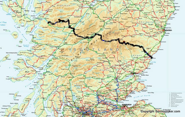
All challengers must begin their journey at one of 14 start points on the west coast of Scotland and sign out to start their journey. This is necessary because, for safety reasons, “Challenge Control” in Montrose keeps track of participants as they make their way cross country. This is very hands-off and requires that you text or call Challenge Control several times during your trip with your current location. You can finish anywhere on the east coast between Fraserburgh and Arbroath, but you must get to Montrose by 5:00 pm on the last day of the event for your crossing to count.
How do you decide where to start and end? While some of the start points are extremely scenic, they can be devilishly hard to get to by rail, bus, or boat because they are so remote. Some start points are also more popular than others, which can be good or bad, depending on how social you want to be. Where you start will also significantly influence the route you take during the first week, since the geography tends to funnel participants together in week two, which is usually much more social.
Maps, Planning Tools, and GPS Apps
OS Maps is the UK’s national mapping agency (like the USGS) and they sell paper and waterproof maps (but don’t currently ship to the US), and maps online. They also have a mobile app and online planning tools. While you may be tempted to carry paper versions of all of the OS maps you need for your route, be forewarned that they are big, bulky, and heavy. The waterproof versions of these maps are also laminated and not printed on waterproof paper, which makes them even heavier than the paper ones. You’ll probably be better off planning your route using an online tool that uses OS Maps and printing that out instead if you want to reduce the weight and bulk that you need to carry.

OS Maps has a simple but effective online planning tool that I like to use in conjunction with their mobile phone app in the field in conjunction with a compass, but there are others available as well including Outdoor Active and Anquet’s OMN3 which licenses the digital maps created by OS Maps as well as others. (I don’t recommend Anquet because the software is quite dated and clunky to use.) All of these tools have import and export capabilities so you can transfer routes between them interchangeably.

Grid References
When you fill out your Route Sheet, you’ll need to use OS Grid References to indicate locations on the map instead of Lat/Lon Coordinates. These divide the UK into a series of squares and then further subdivide these into smaller and smaller quadrants to generate an Ordnance Survey Grid Reference based on the metric system. It’s quite similar to UTM coordinates used in the US. The only difference is that everyone uses them in the UK.
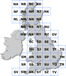
Most online planning tools provide these coordinates with a click of your mouse, which is another reason they’re so convenient to use.
Route Planning Decisions
Scotland has a right-of-way law that permits anyone to walk across private property without prior permission, with the exception of certain properties owned by the Royal Family. This opens up the option for wild and remote cross-country routes, which is one of the main attractions of the TGO Challenge and hiking in Scotland.

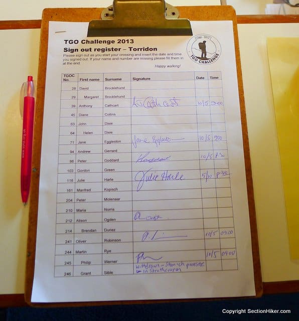
When planning your route, you’ll want to decide whether you want to go high and climb a lot of mountains or stay low and stick to the valleys and lochs. Both are enjoyable and most people do a little of both. If you do plan a high route, you’ll also have to plan out FWA’s for it, which stands for “foul weather alternates”, which is the low-level detour you’ll take when the weather is poor. These must be specified on the route sheet you submit to the Challenge route vetters. An example route sheet is shown above.

You’ll also want to decide whether you want to hike cross country or stick to well-defined paths, direct Land Rover tracks, or paved roads. You’re not allowed to use any wheeled transport on the challenge although you can ride the ferry across Loch Ness if your route requires a crossing.
Some rivers require bridge crossings, so you may find yourself detouring to them for a crossing. Being spring, some of the bridges marked out on your map may no longer exist if they’ve been destroyed by spring flooding. You can usually find this out by asking locals about current conditions on the TGO Facebook Group, which I suggest you join.
Finally, you’ll want to figure out where you can resupply during your trip, including whether you plan to camp out or stay in B&Bs, hostels, mountain bothies, or some combination during your trip.
Route Sharing Sites
There are many ways to research mountains to climb and places to visit along your route. But the most expedient way I’ve found to sort through the hundreds of options available is to reference a website and expert community called WalkHighlands.

They publish GPX files and detailed route descriptions of dozens of classic walks that you can download and read about. You can use these to piece together a much longer route and rest assured that you’ve hit the highlights in the regions you decide to hike through.

Traditional Gatherings

There are a few places where Challengers gather to socialize as they get closer to the east coast. These include:
- Tarfside, southeast of Braemar, which a small village with a convent that serves food and has a social hall/pub that’s opened for the Challenge. Dozens of challengers meet there and pitch their tents on the village green for the night.
- North Water Bridge, which is a campground just west of Montrose, with showers and washing machines.
For dates and other details, inquire on the TGO Facebook page.
The Joy of Planning
While participating in the TGO Challenge is a marvelous scenic and social experience, many Challengers find enormous pleasure in planning their routes during the winter months. I certainly count myself in their number. While this route planning guide is not meant to be exhaustive, it should give you enough information to get started. If you have additional questions, leave a comment below.
For more information about the TGO Challenge, visit the event website.
About the Author
Philip Werner completed the TGO Challenge in 2010 and 2013. He hopes to complete his third coast-to-coast TGO Challenge hike across Scotland in 2024.
Updated 2024.