
The first trail I ever hiked in the White Mountains, the Beaver Brook Trail, climbs Mt Moosilauke (4803′). The initial ascent is a beast of a climb 2000′ up a cliff with iron bars and wooden steps anchored on the rock next to a waterfall that plunges to the valley below. I chose it back then because it was the closest 4000-footer to the Boston area, where I lived then, but little did I know. I’ve climbed that trail several times since then, and it’s been a memorable experience every time.
This trip was no different. The Beaver Brook Trail was the first trail I climbed recently on a one-night 24-mile backpack I did on the trails surrounding Moosilauke before ascending to the summit. Moosilauke is a big mountain and while it takes some effort to climb it, you’d be surprised at how far you have to hike to circumnavigate it.

Route
- Beaver Brook Trail (up from Rt 112)
- Asquam Ridge Trail
- Hurricane Trail
- Glencliff Trail
- Long Pond Rd
- Tunnel Brook Trail
- Benton Trail
- Beaver Brook Trail (up to summit)
- Beaver Brook Trail (down to Rt 112)
While long and hard, with 7250′ of elevation gain, I hadn’t reckoned on rain being a serious factor on this trip but it was. The weather forecast had been benign with a slight chance of rain on day 1 and sunny weather on day 2. Instead, it rained throughout. I don’t know why they even bother forecasting the weather in New Hampshire this summer because it’s often wrong. But if you’re not willing to hike or backpack in the rain you’re not going to be doing much hiking or backpacking.
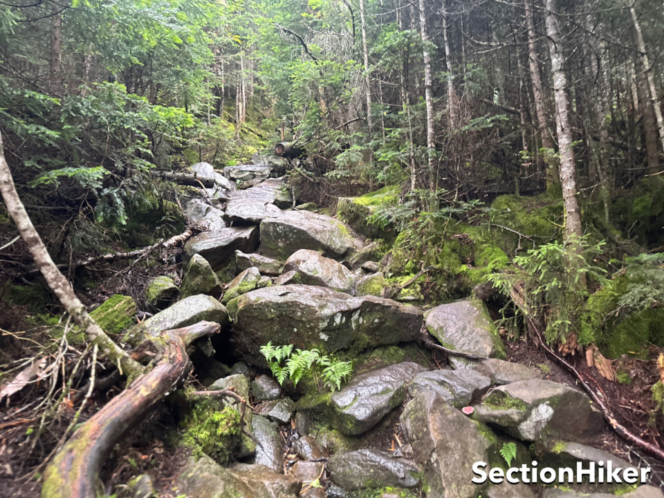
Climbing that first leg up the Beaver Brook Trail was a chore with a full overnight pack, but I made pretty good time, climbing 1000 ft/hour. While the elevation gain is significant, the thing that makes this trail so difficult is the footing, which is full of big rocks requiring careful footwork because they’re constantly wet from the adjacent waterfall. I try to take small steps when climbing up steep inclines because it preserves the big muscles of your legs and helps stave off fatigue, but there was no avoiding it on this climb.

At the top of the climb, I turned on the Asquam Ridge Trail which is much gentler and follows the south “rim” of Moosilauke before dropping down to Dartmouth’s Ravine Lodge, a sprawling lodging complex that’s open to the public. From there, I tried to follow the old Hurricane Trail (by bushwhacking it) but discovered that that section was impassable and has now been rerouted, forking now off the Gorge Brook Trail. I guess I need to update my waterproof maps again (FarOut and Gaia both have it wrong).

Hurricane Mountain is 3000′ peak on the southwest side of Moosilauke and sees a surprising amount of traffic, probably because it links the Appalachian Trail from Glencliff, south of Moosilauke, to Ravine Lodge, letting you bypass the summit. The Hurricane Mtn Trail ends at the Glencliff Trail, which runs down to Sanatorium Road. I followed that road down to Long Pond Rd, which is a dirt Forest Service Rd named #19, and followed it to the start of the Tunnel Brook Trail.

By this time, I was tired and started to wonder where I’d pitch my tent for the night. I’d hiked about 11 miles so far and had planned to camp somewhere along the Tunnel Brook Trail, which has good water access. This trail is pretty remote, traveling up the narrow valley between Mt Moosilauke and My Clough, a trailless peak to the west. The ends of this trail have pretty good camping, but there are a series of beaver ponds in the middle that aren’t so good because they’re so wet.
When I got to that middle section of the Tunnel Brook Trail, the raspberry bushes along the trail were head high, so I had to push through a lot of thorny vegetation. Luckily, I’d made a last-minute clothing change on this trip, switching from the t-shirt and shorts I’ve been wearing most of the summer to a synthetic long-sleeve shirt and long pants instead. This proved to be crucial, both to avoid getting cut up by thorns and to stay warmer in the constant rain.

I kept hiking and covered another 5 miles before calling it a day near the Benton Trail junction. I was pretty exhausted at this point, set up camp, and started making dinner. But then I discovered that I’d forgotten to pack a spoon, my normal trail utensil. I’d packed a dinner of gnocchi, olive oil, and salt which was going to be challenging to eat by hand!
So I boiled a pointed stick with my gnocchi and speared them instead. Luckily my cook pot has drain holes in the lid, so I was able to drain off the cooking water, cover the gnocchi with olive oil and salt and wolf it down. They make a pretty good meal, but next time I want to bring a bigger pot and some tomato sauce and cheese to eat them with. Then I went right to bed.

The next morning my breakfast consisted of instant wheat cereal. To eat this, I made it with an excess of water, so that I could effectively drink it from the cook pot. I usually eat my wheat cereal with a lot of water even when I have a spoon because I view it as calories AND hydration, but this was on the extreme end. I made up a Nalgene full of strong tea and then it started to rain again.
While the Benton Trail requires 3000′ of elevation gain over 3 miles, it is a much easier trail to hike than the Beaver Brook Trail because the trail surface is mostly spruce needles and no big muscle moves are needed. You can really just shuffle along, figuratively speaking. In fact, I think it’s probably the easiest trail to get up to Moosilauke and probably worth the easy 1.8 mile walk from the north trailhead of the Tunnel Brook Trail to get to (I hiked to it from the south end.)

It took three hours to climb and then I found myself back on the Beaver Brook Trail just 0.4 miles from the summit and less than 300′ of elevation to climb. While I knew there would be no summit views since it was raining and blowing pretty hard, I knew I couldn’t just skip the summit and hike out when it was so close.
The Beaver Brook Trail breaks above treeline about one or two-tenths of a mile from the summit and from that point on large rock cairns mark the trail. Visibility was about 25 yards and the wind was howling when I stepped out of the trees, but I’d had the foresight to layer up with a fleece midlayer and rain jacket beforehand. I’ve climbed this mountain over a dozen times so I knew this route and what to expect, but you can only imagine what a newcomer would think.

The powers that be had painted white blazes on the cairns since the last time I hiked this route and trail signs have been put up documenting the trail names since people have ceased to use maps or know which direction they’re headed without their phones. I can’t help but mourn the dumbing down of hiking and backpacking due to the advent of smartphone apps. It’s why I’m drawn to off-trail travel and poorly marked trails, I suppose, if only to keep my brain from atrophying too.
At the summit, I met an Alpine Steward from the Dartmouth Outdoor Club who was rebuilding a scree wall and removing invasive plants, as well as guiding the few hikers crazy enough to hike the peak that day toward the correct trails. It’s been several years since I’ve seen a Steward on Moosilauke and he explained that they’ve only just reactivated the program again. The DOC does a tremendous job maintaining all the White Mountain trails between Hanover and Moosilauke. Really top-notch work.

I sighed in relief when I made it back below treeline and into the protection of the trees. But the toughest part of the day was yet to come: hiking the length of the Beaver Brook Trail back to Rt 112 including a descent of the really steep part I’d hiked up the day before.
The top part of that trail was a mudbath with really deep and unavoidable mud and puddles. I had long given up staying dry at this point, but this was over the top. I can now say that the Beaver Brook Trail is my least favorite trail in the Whites and rank it as one of the 10 hardest. The big descent, while sketchy and slow, was actually a lot easier than the ascent with a full pack. Still, I was happy when I got back down in one piece and could peel off my wet clothes for the drive home.

This was a good trip but challenging. It would have been much more pleasant in fine weather, but I’m still glad I went. I enjoy the reset that solo backpacking trips provide and plan to continue them until I’m no longer able…which hopefully will be many years to come.
Recommended Guidebooks and Maps:
SectionHiker is reader-supported. We only make money if you purchase a product through our affiliate links. Help us continue to test and write unsponsored and independent gear reviews, beginner FAQs, and free hiking guides.