
Franconia Ridge is lovely to hike any time of year. But it can get pretty hairy to climb in winter when it’s cold and the wind is blowing hard. The best days don’t come around that often so you need to watch the weather forecast closely and make time for a hike when a good weather window presents itself.
I got one of those weather windows last week, right before the Martin Luther King holiday, when the forecast called for 20-degree temperatures and low winds, decreasing to 10-15 mph in the afternoon. That is exceptional for January, so I cleared my calendar and decided to go for it.
My goal for this hike was to climb 2 five thousand footers, Mt Lincoln (5080′) and Mt Lafayette (5242′). This is usually done as a loop hike, climbing a peak adjacent to Lincoln on the ridge called Little Haystack (4760′), before following the Franconia Ridge Trail over Lincoln, a minor peak named Mt Truman (5020′), and then Lafayette, before descending Lafayette to the AMC’s Greenleaf Hut (closed in winter), and hiking back down to the Franconia Notch trailhead. The total loop is close to 9 miles in length with 4000′ of elevation gain. It’s a serious hike and tougher in winter when you have to carry a lot more gear.

We’d experienced quite heavy snowfall the prior week and I didn’t know what kind of snow conditions would be on the ridge above treeline. No trip reports were posted on NETrailConditions.com, which is how serious hikers share that information in the White Mountains.
So I packed all the gear I might need for the traverse because I didn’t want to get up there and not be able to finish the route. I’ve used all of the gear below except the Dion Snowshoes, on previous winter hikes along Franconia Ridge, so this wasn’t my first rodeo.
- Hillsound Trail Crampons
- Dion Snowshoes
- Grivel G1 Universal Crampons
- Camp Corsa Ice Axe
- North45 Balaclava
- Smith Ski Goggles
- Multiple sets of gloves, food, drink, and layers
The day of the hike, I met two friends who wanted to join me and we got a civilized start at 8:30 am. We knew it would take us about 3 hours to get to treeline, a 3.2 mile hike up with 3000′ of elevation gain. It’s another 2.8 miles along the ridge and down the west face of Mt Lafayette to get to the safety of treeline at the AMC Hut, and 2.9 miles more to get back down to the trailhead. Our priority was to get back down to treeline and the hut before dark, since the final descent to the trailhead can be done by headlamp fairly safely.
We set out and conditions were decent but not great. The trail was covered by a foot or so of snow and had been post-holed by people who hadn’t worn snowshoes and then frozen. While annoying, it meant we could hike in their footsteps, quite literally, all the way to treeline, without any traction aids. All of the water crossings en route were bridged on the way up and we made pretty decent time.
Just below treeline, my two companions decided to bail because they were having a bad day – it happens – and they headed back down the trail. I continued up, judging the weather conditions safe enough for a solo traverse. I am cautious but I wanted to climb Lincoln and Lafayette in January for my Grid and judged the risk level as acceptable.

There was just enough wind that I decided to protect my face by wearing a balaclava when you get to treeline on Little Haystack there are some rocks at the summit you can shelter behind to get out of the wind, so I ducked between them and adjusted my gear for the ridge hike over Lincoln, Truman, and Lafayette The sun was warm but there was a breeze so I opted to put on a balaclava to shield my face and full crampons for traction. Then I set off.
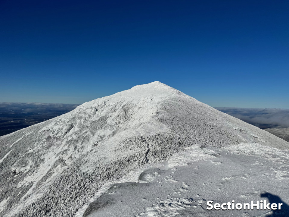
The ridge trail was covered with dry powdery snow about 6″ deep interspersed with stretches of ice. The Franconia Ridge is fairly level between Lincoln and Lafayette, but there are rocky outcrops and scrambles that one needs to climb over or around. I prefer the surety of crampons over snowshoes for scrambling, but it was a toss-up as to which would have been the better option.

I only had to hike a short distance north to climb Mt Lincoln so I set off. There was still some undercast in the valley below which I reveled in as I walked. I soon passed a group I’d seen at the trailhead heading south and started the climb up Lincoln which involved clambering over the ice-blasted rock outcroppings. My crampons made this easy.
I summitted Lincoln and took in the view, before hiking down the other side to the next objective known as Mt Truman which is a bump along the ridge between Mt Lincoln and Mt Lafayette. Mt Truman and for the matter Little Haystack are 4000 footers, but not on the AMC’s White Mountain Four Thousand Footer List. Instead, they’re on the Trailwrights 72 peakbagging list which is much harder to finish because it includes 24 more four-thousand footers and you can only count one peak per hike toward completion. That means it takes four separate hikes to climb Litte Haystack, Mt Lincoln, Mt Truman, and Mt Lafayette.
Truman is just a bump along the ridge and is easy to top, but it has a tricky descent down the other side, so I opted to hike around it using a shortcut I’ve used in the past. But there’s been so little traffic on the Franconia Ridge Trail recently, that I ended up stepping into a spruce trap. This is a winter hazard where snow covers the voids between bushes and if you step on one you can sink into the void and not be able to get out.
I did sink in, but quickly realized what was happening and started to back away, only to find that I couldn’t backtrack. I wiggled my feet to break free and that’s when I think I lost one of my crampons. Not good. I lunged forward across the spruce trap and managed to scramble out of it on the other side before sinking further. Good thing too, because I didn’t want to die there alone.
I quickly put the incident out of my mind and headed toward Lafayette, passing through a stand of krummholz (dwarf shrubbery) before emerging back out in the open on the other side. Lafayette was about 200 feet of elevation gain farther up and I felt myself tiring. But I still had plenty of daylight left, so I slowed my pace and took smaller steps until I reached the summit sign.
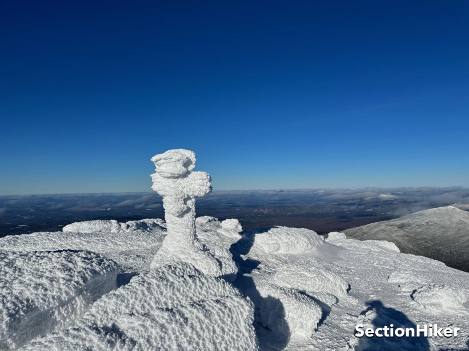
This is where previous experience paid off. When you get to Lafayette, you need to turn west to descend to the Greenleaf Hut and not continue north. The trail down can be a little tricky to follow, especially since it’s only marked by snow-covered rock cairns that look like all the other rocks piled on the side of Lafayette. The majority of fatalities on Lafayette in winter occur when people miss that turn or lose the trail on the way down and end up descending into a steep gully north of the actual trail. I had excellent visibility on my hike, but you can really get into trouble when you can’t see the cairns marking the route going down.

When I got down to the hut, I refueled, eating and drinking. I still had two hours before sunset and I was confident that I’d make it back down to the trailhead by sunset at 4:30. The trail below the hut (called the Old Bridle Path) runs over a series of peaklets that are known as Agony Ridge. While they take some effort to climb, I made excellent time on the descent, getting back to the trailhead by 4:00 pm.
I’d had fantastic weather and besides my spruce trap experience, it’d been a fairly easy hike. I was elated to “grid out” Lincoln and Lafayette for my 4000 Footer Grid, meaning I’ve now hiked them in every calendar month of the year. But this is one route I’m sure I’ll hike again and again in the future: it’s just too beautiful to pass up.
Recommended Guidebooks and Maps:
SectionHiker is reader-supported. We only make money if you purchase a product through our affiliate links. Help us continue to test and write unsponsored and independent gear reviews, beginner FAQs, and free hiking guides.